 BECE Past Questions
BECE 1993 Social Studies Past Questions and Answers
40 objective questions and 6 theory questions from the 1993 BECE Social Studies paper. Answers and worked solutions for questions 1 to 10 are below; the rest are free in the app.
Practise this paper free, online or offline


On an iPhone? Download on the App Store
On Android? Get it on Google Play
Paper 1: Objectives
-
The colour used for showing rivers and lakes on topographical maps is
- A. red
- B. blue
- C. brown
- D. green
- E. yellow
Answer: B -
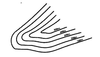
Use the contour line above to answer the question below. The vertical interval is- A. 100 m
- B. 200 m
- C. 300 m
- D. 400 m
- E. 500 m
Answer: A -
Use the contour line above to answer the question below. The landform shown is a- A. cliff
- B. valley
- C. ridge
- D. plateau
- E. spur
Answer: E -
How many days does the earth take to complete its journey around the sun?
- A. 360 ¼
- B. 365
- C. 365 ¼
- D. 366
- E. 366 ¼
Answer: C -
The revolution of the earth around the sun is the main cause of
- A. the rise and fall in the sea level
- B. day and night
- C. changes in wind direction
- D. the four seasons
- E. changes in the direction of the ocean current
Answer: D -
When it is 2:00 pm at a place on longitude 0°, the time at a place on longitude 45°W will be
- A. 10:00 am
- B. 11:00 am
- C. 12:00 noon
- D. 4:00 pm
- E. 5:00 pm
Answer: B -
When the sun is overhead on the Tropic of Capricorn, areas in the Southern Hemisphere experience
- A. equinoxes
- B. spring
- C. summer
- D. autumn
- E. winter
Answer: C -
Which of the following is not a coastal landform?
- A. Cliff
- B. Estuary
- C. Sandbar
- D. Lagoon
- E. Inselberg
Answer: E -
A common feature found along the lower course of a river is a
- A. meander
- B. gorge
- C. tributary
- D. waterfall
- E. mountain
Answer: A -
Use the table below, which shows the temperature and rainfall figures recorded for town A to answer the question below. In which month was the highest rainfall recorded?
Climate Months Jan Feb Mar Apr May Jun Jul Aug Sept Oct Nov Dec Temperature °C 20 28 30 30 25 26 30 20 20 21 20 20 Rainfall (mm) 10 20 30 56 110 120 100 35 35 30 20 10 - A. April
- B. May
- C. June
- D. July
- E. August
Answer: C
Answers and solutions for questions 11 to 40 are free in the BECE Past Questions app, with timed practice and offline study.
-
Use the table below, which shows the temperature and rainfall figures recorded for town A to answer the question below. The total amount of rainfall recorded for the year was
Climate Months Jan Feb Mar Apr May Jun Jul Aug Sept Oct Nov Dec Temperature °C 20 28 30 30 25 26 30 20 20 21 20 20 Rainfall (mm) 10 20 30 56 110 120 100 35 35 30 20 10 - A. 576 mm
- B. 607 mm
- C. 667 mm
- D. 706 mm
- E. 767 mm
-
Use the table below, which shows the temperature and rainfall figures recorded for town A to answer the question below. The annual range of temperature was
Climate Months Jan Feb Mar Apr May Jun Jul Aug Sept Oct Nov Dec Temperature °C 20 28 30 30 25 26 30 20 20 21 20 20 Rainfall (mm) 10 20 30 56 110 120 100 35 35 30 20 10 - A. 10 °C
- B. 20 °C
- C. 21 °C
- D. 25 °C
- E. 30 °C
-
Which of the following statements best describes the position of Ghana?
- A. Ghana is to the east of the Republic of Togo
- B. Burkina Faso is the southern neighbour of Ghana
- C. Ghana is to the immediate west of Niger
- D. Ghana is to the immediate east of La Cote d'Ivoire
- E. Ghana is boarded to the north by the Gulf of Guinea.
-
The main vegetation types found in the Northern parts of Ghana is
- A. evergreen forest
- B. mangrove swamp
- C. hot desert
- D. semi-deciduous forest
- E. savanna grassland
-
The hot dry winds that blow over most parts of Ghana during the harmattan are the
- A. south-west monsoon
- B. south easterly winds
- C. north-westerly winds
- D. north-east trade winds
- E. easterly winds
-
The most important export commodity for Ghana is
- A. timber
- B. cocoa
- C. coffee
- D. pineapple
- E. kola
-
Which of the following minerals is not mined in Ghana?
- A. Gold
- B. Diamond
- C. Tin
- D. Manganese
- E. Bauxite
-
The main cause of the formation of the Volta Lake was the
- A. construction of a dam across the Volta River
- B. generation of hydro-electric power from the Volta River
- C. activities of the fishermen along the Volta River
- D. construction of a bridge across the Volta River
- E. development of river transportation on the Volta River
-
Which of the following may help solve the problem of forest destruction in Ghana?
- A. Bush burning
- B. Lumbering
- C. Mining
- D. Farming
- E. Afforestation
-
The most popular mode of transport in Ghana is by
- A. sea
- B. rail
- C. air
- D. road
- E. river
-
All the big textile factories in Ghana are located at
- A. Tamale
- B. Winneba
- C. Tema
- D. Kumasi
- E. Nsawam
-
Which of the following do people belonging to the same ethnic group in Ghana have in common?
- A. Clothes
- B. Language
- C. Name
- D. Occupation
- E. Religion
-
Which of the following is not associated with celebration of festivals in Ghana?
- A. Planning Developmental Projects
- B. Cleansing Ancestral Stools
- C. Feasting and Merry-making
- D. Paying homage of chiefs
- E. Establishing a new settlement
-
In the history of Ghana, Yaa Asantewaa is noted for the
- A. War of 1901
- B. Akatamanso war
- C. War of 1874
- D. Adaamanso war
- E. Feyiase war
-
The Mamprusi in Ghana are believed to have come from
- A. the Upper East Region
- B. Western Region
- C. southern Ghana
- D. eastern part of Lake Chad
- E. western part of Lake Chad
-
The Accelerated Development Plan of education was introduced in Ghana in 1951 for the following reasons except
- A. reduction of primary school education to six years
- B. setting up many teacher training colleges
- C. reduction in the number of job opportunities for school leavers
- D. helping of some workers study privately to enter universities
- E. increasing of the number of university students
-
The second Republic of Ghana covered the period
- A. 1957 to 1960
- B. 1960 to 1966
- C. 1966 to 1969
- D. 1969 to 1972
- E. 1972 to 1979
-
The struggle for the independence of Ghana from 1951 to 1957 was led by
- A. Dr J.B. Danquah
- B. Mr Ako Adjei
- C. Dr K.A. Busia
- D. Mr K.A. Gbedemah
- E. Dr Kwame Nkrumah
-
Who was the chairman of the Center for Civic Education in Ghana?
- A. Dr K.A. Busia
- B. Mr Kojo Botsio
- C. Dr John Bilson
- D. Mr A Casely-Hayford
- E. Mr K.A. Gbedemah
-
The 1979 Constitution of Ghana was the
- A. first after independence
- B. second after independence
- C. third after independence
- D. fourth after independence
- E. fifth after independence
-
Trade between two countries is called
- A. barter trade
- B. surplus trade
- C. domestic trade
- D. multilateral trade
- E. bilateral trade
-
Which of the following Educational Policies emphasized the education of the girl-child in Ghana?
- A. Education Act of 1961
- B. Education Act of 1951
- C. FCUBE of 1996
- D. Education Reforms of 1987
- E. New Reform of 1974
-
Most of the lakes in East Africa were formed as a result of the
- A. rift valley system
- B. fold mountain system
- C. action of volcanoes
- D. action of wind
- E. action of sea waves
-
There is a large population of white settlers in the highland areas of East Africa mainly because
- A. of the beautiful natural scenery
- B. it is safe to travel along the steep slopes
- C. of the sunshine and warmth
- D. of the availability of water
- E. of the cool, healthy and pleasant environment
-
Which of the following African countries is a leading producer of cotton?
- A. Kenya
- B. Malawi
- C. Egypt
- D. Zambia
- E. Uganda
-
Cotton is the raw material used in making
- A. paper
- B. clothes
- C. shoes
- D. cigarettes
- E. furniture
-
All the following are metallic minerals except
- A. bauxite
- B. copper
- C. gold
- D. diamond
- E. manganese
-
In which of the following countries is the system of apartheid commonly practiced
- A. Egypt
- B. Mauritania
- C. Kenya
- D. Nigeria
- E. South Africa
-
Which of the following organizations was set up mainly to help solve the problem of hunger and disease in the world?
- A. The FAO
- B. The ECA
- C. The UNDP
- D. The OAU
- E. The UNHCR
-
The UNO has all the following aims except
- A. maintenance of international peace and security
- B. development of friendly relations among nations
- C. removal of unpopular heads of states of member countries
- D. solving international problems
- E. promotion of respect for human rights
Paper 2: Theory
- a) Use the map of Tamo to answer Question 1
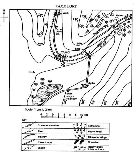
What is the direction of Kissi from Tamo?
b) Calculate the distance in kilometres along the class one road from Aplu to the bridge across River Lawi.
c) What is the direction of flow of River Lawi?
d) Name the feature marked X at the mouth of River Lawi.
e) Mention the main two lines of communication of the area.
f) Using the map only, name two products that are likely to be exported through the Tamo port. - a) Name three types of rainfall.
b) With the help of a diagram describe how any one type of rainfall is formed. - a) Mention four qualities that made Osei Tutu a good ruler of the Asantes.
b) What three things did Osei Tutu do to keep the Asantes united? - a) Mention four sources from which fish are caught in Ghana.
b) Describe two ways by which the fish are caught.
c) Name:
i) Two types of fish caught.
ii) Two methods of preserving fish. - a) What was the major activity which brought foreigners into West Africa?
b) What four effects did the coming of the foreigners have on the lives of the people of West Africa? - a) Mention five achievements of the Aborigines Rights Protection Society (A.R.P.S).
b) Give five reasons why the Aborigines Rights Protection Society collapsed.
Worked solutions to the theory questions are free in the app.
 All answers free on Google Play